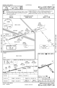
IAC chart of KSRR
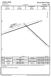
 ADC chart of KSRR
 Satellite view of KSRR
ADC chart of KSRR
Satellite view of KSRR
Sorry, we have no imagery here.
Sorry, we have no imagery here.
Sorry, we have no imagery here.
Sorry, we have no imagery here.
Sorry, we have no imagery here.
Sorry, we have no imagery here.


KSRR - Sierra Blanca Rgnl
Located in Ruidoso, United States
ICAO - SRR, IATA -
Data provided by AirmateGeneral information
Coordinates: N33°27'39" W105°31'49"
Elevation is 6813 feet MSL.
Magnetic variation is 10° East View others Airports in New Mexico
Operational data
Special qualification required
Current time UTC:
Current local time:
Weather
METAR: KSRR 191815Z AUTO 31026G37KT 10SM SCT080 16/M07 A2995 RMK AO2
Communications frequencies: [VIEW]
Runways:
| RWY identifier | QFU | Length (ft) | Width (ft) | Surface | LDA (ft) |
| 06 | 71° | 8120 | 100 | ASPH | 8120 |
| 24 | 251° | 8120 | 100 | ASPH | 8120 |
| 12 | 132° | 6309 | 75 | ASPH | 6309 |
| 30 | 312° | 6309 | 75 | ASPH | 6309 |
Airport contact information
Address: Ruidoso United States
Satellite view of KSRR
Sorry, we have no imagery here.
Sorry, we have no imagery here.
Sorry, we have no imagery here.
Sorry, we have no imagery here.
Sorry, we have no imagery here.
Sorry, we have no imagery here.