IAC chart of KSQI
 ADC chart of KSQI
 Satellite view of KSQI
ADC chart of KSQI
Satellite view of KSQI
Sorry, we have no imagery here.
Sorry, we have no imagery here.
Sorry, we have no imagery here.
Sorry, we have no imagery here.
Sorry, we have no imagery here.
Sorry, we have no imagery here.


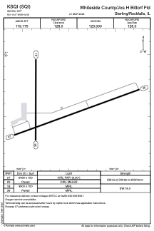
KSQI - Whiteside County/Jos H Bittorf Fld
Located in Sterling/Rockfalls, United States
ICAO - SQI, IATA -
Data provided by AirmateGeneral information
Coordinates: N41°44'34" W89°40'35"
Elevation is 647 feet MSL.
Magnetic variation is -02° East View others Airports in Illinois
Operational data
Special qualification required
Current time UTC:
Current local time:
Weather
METAR: KSQI 061256Z AUTO 29011KT 10SM CLR M04/M06 A2989 RMK AO2 SLP128 T10391061 PWINO FZRANO
Communications frequencies: [VIEW]
Runways:
| RWY identifier | QFU | Length (ft) | Width (ft) | Surface | LDA (ft) |
| 07 | 70° | 6499 | 150 | ASPH | |
| 25 | 250° | 6499 | 150 | ASPH | |
| 18 | 180° | 3900 | 100 | ASPH | |
| 36 | 0° | 3900 | 100 | ASPH |
Airport contact information
Address: Sterling/Rockfalls United States
Other aviation service providers
Repair station

Flight schools

Twin Cities Air Activities Club
Twin Cities Air Activities Club
webmaster@twincitiesflyingclub.com+1(815)631-5958
Satellite view of KSQI
Sorry, we have no imagery here.
Sorry, we have no imagery here.
Sorry, we have no imagery here.
Sorry, we have no imagery here.
Sorry, we have no imagery here.
Sorry, we have no imagery here.