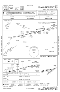
IAC chart of KSOW
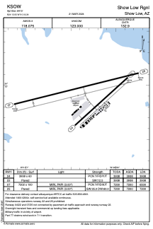
 ADC chart of KSOW
 Satellite view of KSOW
ADC chart of KSOW
Satellite view of KSOW
Sorry, we have no imagery here.
Sorry, we have no imagery here.
Sorry, we have no imagery here.
Sorry, we have no imagery here.
Sorry, we have no imagery here.
Sorry, we have no imagery here.


KSOW - Show Low Rgnl
Located in Show Low, United States
ICAO - SOW, IATA - SOW
Data provided by AirmateGeneral information
Coordinates: N34°15'56" W110°0'20"
Elevation is 6415 feet MSL.
Magnetic variation is 10° East View others Airports in Arizona
Operational data
Special qualification required
Current time UTC:
Current local time:
Weather
METAR: KSOW 201755Z AUTO 35008G17KT 10SM CLR 18/M11 A3024 RMK AO2
Communications frequencies: [VIEW]
Runways:
| RWY identifier | QFU | Length (ft) | Width (ft) | Surface | LDA (ft) |
| 04 | 48° | 3938 | 60 | ASPH | 3938 |
| 22 | 228° | 3938 | 60 | ASPH | 3938 |
| 07 | 76° | 7202 | 100 | ASPH | 6500 |
| 25 | 256° | 7202 | 100 | ASPH | 7200 |
Airport contact information
Address: Show Low United States
Satellite view of KSOW
Sorry, we have no imagery here.
Sorry, we have no imagery here.
Sorry, we have no imagery here.
Sorry, we have no imagery here.
Sorry, we have no imagery here.
Sorry, we have no imagery here.