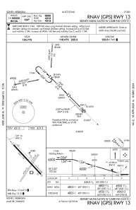
IAC chart of KSNY
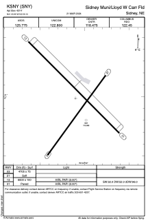
 ADC chart of KSNY
 Satellite view of KSNY
ADC chart of KSNY
Satellite view of KSNY
Sorry, we have no imagery here.
Sorry, we have no imagery here.
Sorry, we have no imagery here.
Sorry, we have no imagery here.
Sorry, we have no imagery here.


KSNY - Sidney Muni/Lloyd W Carr Fld
Located in Sidney, United States
ICAO - SNY, IATA -
Data provided by AirmateGeneral information
Coordinates: N41°5'59" W102°59'6"
Elevation is 4314 feet MSL.
Magnetic variation is 11° East View others Airports in Nebraska
Operational data
Special qualification required
Current time UTC:
Current local time:
Weather
METAR: KSNY 131553Z AUTO 36020G29KT 10SM CLR 12/04 A2990 RMK AO2 PK WND 35035/1459 SLP100 T01220044
TAF: KSNY 131139Z 1312/1412 33013KT P6SM SKC FM131600 34022G31KT P6SM FEW230 FM140200 32014KT P6SM BKN230
Communications frequencies: [VIEW]
Runways:
| RWY identifier | QFU | Length (ft) | Width (ft) | Surface | LDA (ft) |
| 03 | 36° | 4705 | 75 | GRASS | |
| 21 | 216° | 4705 | 75 | GRASS | |
| 13 | 135° | 6600 | 100 | CONC | |
| 31 | 315° | 6600 | 100 | CONC |
Airport contact information
Address: Sidney United States
Satellite view of KSNY
Sorry, we have no imagery here.
Sorry, we have no imagery here.
Sorry, we have no imagery here.
Sorry, we have no imagery here.
Sorry, we have no imagery here.