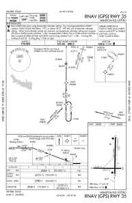
IAC chart of KSNK
 ADC chart of KSNK
 Satellite view of KSNK
ADC chart of KSNK
Satellite view of KSNK
Sorry, we have no imagery here.
Sorry, we have no imagery here.
Sorry, we have no imagery here.
Sorry, we have no imagery here.
Sorry, we have no imagery here.
Sorry, we have no imagery here.


KSNK - Winston Fld
Located in Snyder, United States
ICAO - SNK, IATA -
Data provided by AirmateGeneral information
Coordinates: N32°41'36" W100°57'2"
Elevation is 2430 feet MSL.
Magnetic variation is 08° East View others Airports in Texas
Operational data
Special qualification required
Current time UTC:
Current local time:
Weather
METAR: KSNK 131515Z AUTO 22013G16KT 10SM CLR 22/04 A2994 RMK AO2 T02200043
Communications frequencies: [VIEW]
Runways:
| RWY identifier | QFU | Length (ft) | Width (ft) | Surface | LDA (ft) |
| 08 | 90° | 4200 | 75 | ASPH | |
| 26 | 270° | 4200 | 75 | ASPH | |
| 17 | 180° | 5599 | 100 | ASPH | |
| 35 | 0° | 5599 | 100 | ASPH |
Airport contact information
Address: Snyder United States
Satellite view of KSNK
Sorry, we have no imagery here.
Sorry, we have no imagery here.
Sorry, we have no imagery here.
Sorry, we have no imagery here.
Sorry, we have no imagery here.
Sorry, we have no imagery here.