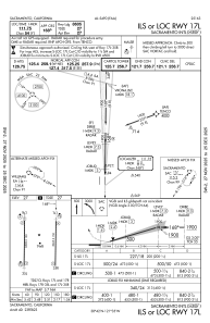
IAC chart of KSMF
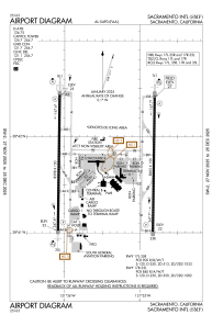
 ADC chart of KSMF
 Satellite view of KSMF
ADC chart of KSMF
Satellite view of KSMF
Sorry, we have no imagery here.
Sorry, we have no imagery here.
Sorry, we have no imagery here.
Sorry, we have no imagery here.
Sorry, we have no imagery here.
Sorry, we have no imagery here.


KSMF - Sacramento Intl
Located in Sacramento, United States
ICAO - SMF, IATA - SMF
Data provided by AirmateGeneral information
Coordinates: N38°41'44" W121°35'27"
Elevation is 26 feet MSL.
Magnetic variation is 13° East View others Airports in California
Operational data
Special qualification required
Current time UTC:
Current local time:
Weather
METAR: KSMF 201753Z 33009KT 10SM CLR 26/02 A3004 RMK AO2 SLP170 T02560022 10256 20150 58001
TAF: KSMF 201720Z 2018/2118 32010KT P6SM SKC FM210200 VRB05KT P6SM SKC FM211200 34005KT P6SM FEW250
Communications frequencies: [VIEW]
Runways:
| RWY identifier | QFU | Length (ft) | Width (ft) | Surface | LDA (ft) |
| 17L | 181° | 8605 | 150 | CONC | 8605 |
| 35R | 1° | 8605 | 150 | CONC | 8605 |
| 17R | 181° | 8598 | 150 | CONC | 8598 |
| 35L | 1° | 8598 | 150 | CONC | 8598 |
Airport contact information
Address: Sacramento United States
Satellite view of KSMF
Sorry, we have no imagery here.
Sorry, we have no imagery here.
Sorry, we have no imagery here.
Sorry, we have no imagery here.
Sorry, we have no imagery here.
Sorry, we have no imagery here.