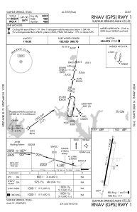
IAC chart of KSLR
 ADC chart of KSLR
 Satellite view of KSLR

ADC chart of KSLR
Satellite view of KSLR
Sorry, we have no imagery here.
Sorry, we have no imagery here.
Sorry, we have no imagery here.
Sorry, we have no imagery here.
Sorry, we have no imagery here.
Sorry, we have no imagery here.


KSLR - Sulphur Springs Muni
Located in Sulphur Springs, United States
ICAO - SLR, IATA -
Data provided by AirmateGeneral information
Coordinates: N33°9'35" W95°37'16"
Elevation is 489 feet MSL.
Magnetic variation is 03° East View others Airports in Texas
Operational data
Special qualification required
Current time UTC:
Current local time:
Weather
METAR: KSLR 151515Z AUTO 23005KT 4SM HZ SCT026 SCT033 17/04 A2946 RMK AO2 T01650040
Communications frequencies: [VIEW]
Runways:
| RWY identifier | QFU | Length (ft) | Width (ft) | Surface | LDA (ft) |
| 01 | 10° | 5001 | 75 | CONC | |
| 19 | 190° | 5001 | 75 | CONC |
Airport contact information
Address: Sulphur Springs United States
Other aviation service providers
Flight schools

Satellite view of KSLR
Sorry, we have no imagery here.
Sorry, we have no imagery here.
Sorry, we have no imagery here.
Sorry, we have no imagery here.
Sorry, we have no imagery here.
Sorry, we have no imagery here.