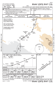
IAC chart of KSLI
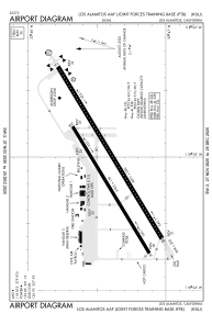
 ADC chart of KSLI
 Satellite view of KSLI
ADC chart of KSLI
Satellite view of KSLI
Sorry, we have no imagery here.
Sorry, we have no imagery here.
Sorry, we have no imagery here.
Sorry, we have no imagery here.
Sorry, we have no imagery here.
Sorry, we have no imagery here.


KSLI - Los Alamitos Aaf
Located in Los Alamitos, United States
ICAO - SLI, IATA -
Data provided by AirmateGeneral information
Coordinates: N33°47'24" W118°3'5"
Elevation is 35 feet MSL.
Magnetic variation is 12° East View others Airports in California
Operational data
Special qualification required
Current time UTC:
Current local time:
Weather
METAR: KSLI 200255Z AUTO 17004KT 6SM HZ CLR 20/15 A2987 RMK AO2 SLP118 T01970147 54000 $
TAF: TAF KSLI 192100Z 1921/2103 VRB06KT 9999 SKC QNH2994INS BECMG 2012/2013 VRB06KT 9000 BR FEW020 QNH2996INS BECMG 2015/2016 VRB06KT 9999 NSW FEW030 QNH2996INS TX26/2000Z TN16/2014Z
Communications frequencies: [VIEW]
Runways:
| RWY identifier | QFU | Length (ft) | Width (ft) | Surface | LDA (ft) |
| 04L | 0° | 5901 | 150 | OTHER | |
| 22R | 0° | 5901 | 150 | OTHER | |
| 04R | 0° | 7999 | 200 | OTHER | |
| 22L | 0° | 7999 | 200 | OTHER |
Airport contact information
Address: Los Alamitos United States
Satellite view of KSLI
Sorry, we have no imagery here.
Sorry, we have no imagery here.
Sorry, we have no imagery here.
Sorry, we have no imagery here.
Sorry, we have no imagery here.
Sorry, we have no imagery here.