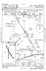
IAC chart of KSLE
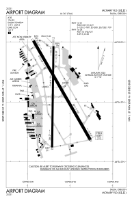
 ADC chart of KSLE
 Satellite view of KSLE
ADC chart of KSLE
Satellite view of KSLE
Sorry, we have no imagery here.
Sorry, we have no imagery here.
Sorry, we have no imagery here.
Sorry, we have no imagery here.
Sorry, we have no imagery here.
Sorry, we have no imagery here.


KSLE - Mcnary Fld
Located in Salem, United States
ICAO - SLE, IATA - SLE
Data provided by AirmateGeneral information
Coordinates: N44°54'34" W123°0'9"
Elevation is 213 feet MSL.
Magnetic variation is 17° East View others Airports in Oregon
Operational data
Special qualification required
Current time UTC:
Current local time:
Weather
METAR: KSLE 291556Z 20010KT 10SM BKN039 BKN047 OVC060 07/03 A3011 RMK AO2 SLP196 T00720033
TAF: KSLE 291131Z 2912/3012 18008KT P6SM SCT025 OVC050 FM292300 35003KT P6SM SCT035 BKN150
Communications frequencies: [VIEW]
Runways:
| RWY identifier | QFU | Length (ft) | Width (ft) | Surface | LDA (ft) |
| 13 | 150° | 5811 | 150 | ASPH | 5811 |
| 31 | 330° | 5811 | 150 | ASPH | 5811 |
| 16 | 181° | 5146 | 100 | ASPH | 5145 |
| 34 | 1° | 5146 | 100 | ASPH | 5145 |
| H1 | 0° | 0 | 0 | UNK |
Airport contact information
Address: Salem United States
Other aviation service providers
Flight schools

Satellite view of KSLE
Sorry, we have no imagery here.
Sorry, we have no imagery here.
Sorry, we have no imagery here.
Sorry, we have no imagery here.
Sorry, we have no imagery here.
Sorry, we have no imagery here.