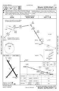
IAC chart of KSJN
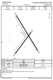
 ADC chart of KSJN
 Satellite view of KSJN
ADC chart of KSJN
Satellite view of KSJN
Sorry, we have no imagery here.
Sorry, we have no imagery here.
Sorry, we have no imagery here.
Sorry, we have no imagery here.
Sorry, we have no imagery here.
Sorry, we have no imagery here.


KSJN - St Johns Industrial Air Park
Located in St Johns, United States
ICAO - SJN, IATA - SJN
Data provided by AirmateGeneral information
Coordinates: N34°31'7" W109°22'44"
Elevation is 5736 feet MSL.
Magnetic variation is 12° East View others Airports in Arizona
Operational data
Special qualification required
Current time UTC:
Current local time:
Weather
METAR: KSJN 220954Z AUTO 20005KT 10SM CLR 13/M11 A3013 RMK AO2 SLP112 T01281111
Communications frequencies: [VIEW]
Runways:
| RWY identifier | QFU | Length (ft) | Width (ft) | Surface | LDA (ft) |
| 03 | 37° | 3400 | 60 | ASPH | |
| 21 | 217° | 3400 | 60 | ASPH | |
| 14 | 148° | 5322 | 75 | ASPH | |
| 32 | 328° | 5322 | 75 | ASPH |
Airport contact information
Address: St Johns United States
Satellite view of KSJN
Sorry, we have no imagery here.
Sorry, we have no imagery here.
Sorry, we have no imagery here.
Sorry, we have no imagery here.
Sorry, we have no imagery here.
Sorry, we have no imagery here.