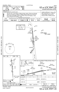
IAC chart of KSGR
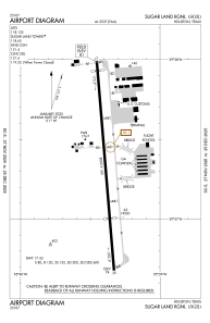
 ADC chart of KSGR
 Satellite view of KSGR
ADC chart of KSGR
Satellite view of KSGR
Sorry, we have no imagery here.
Sorry, we have no imagery here.
Sorry, we have no imagery here.
Sorry, we have no imagery here.
Sorry, we have no imagery here.
Sorry, we have no imagery here.


KSGR - Sugar Land Rgnl
Located in Houston, United States
ICAO - SGR, IATA -
Data provided by AirmateGeneral information
Coordinates: N29°37'20" W95°39'24"
Elevation is 81 feet MSL.
Magnetic variation is 05° East View others Airports in Texas
Operational data
Special qualification required
Current time UTC:
Current local time:
Weather
METAR: KSGR 041653Z 32007KT 10SM -RA FEW080 SCT090 OVC110 23/21 A3001 RMK AO2 PK WND 01028/1554 LTG DSNT E TSE1557 SLP164 P0020 T02280206
TAF: KSGR 041654Z 0417/0512 VRB05KT P6SM VCSH BKN040 BKN250 FM042300 VRB05KT P6SM BKN040 BKN250
Communications frequencies: [VIEW]
Runways:
| RWY identifier | QFU | Length (ft) | Width (ft) | Surface | LDA (ft) |
| 17 | 175° | 8000 | 100 | CONC | |
| 35 | 355° | 8000 | 100 | CONC |
Airport contact information
Address: Houston United States
Other aviation service providers
Flight schools

Satellite view of KSGR
Sorry, we have no imagery here.
Sorry, we have no imagery here.
Sorry, we have no imagery here.
Sorry, we have no imagery here.
Sorry, we have no imagery here.
Sorry, we have no imagery here.