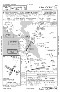
IAC chart of KSFO
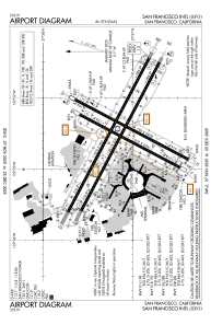
 ADC chart of KSFO
 Satellite view of KSFO
ADC chart of KSFO
Satellite view of KSFO
Sorry, we have no imagery here.
Sorry, we have no imagery here.
Sorry, we have no imagery here.
Sorry, we have no imagery here.
Sorry, we have no imagery here.
Sorry, we have no imagery here.


KSFO - San Francisco Intl
Located in San Francisco, United States
ICAO - SFO, IATA - SFO
Data provided by AirmateGeneral information
Coordinates: N37°37'8" W122°22'32"
Elevation is 13 feet MSL.
Magnetic variation is 14° East View others Airports in California
Operational data
Special qualification required
Current time UTC:
Current local time:
Weather
METAR: KSFO 311756Z 25012G23KT 10SM FEW006 SCT048 14/06 A3001 RMK AO2 PK WND 27026/1658 RAB02E14 SLP163 P0000 60000 T01390061 10139 20117 53008
TAF: KSFO 311740Z 3118/0124 23012G22KT P6SM VCSH FEW005 SCT030 BKN060 FM312100 25020G30KT 5SM -SHRA FEW015 SCT030 BKN050 FM010300 25013KT P6SM FEW050 SCT070 FM011100 24012G22KT P6SM -SHRA SCT030 BKN050
Communications frequencies: [VIEW]
Runways:
| RWY identifier | QFU | Length (ft) | Width (ft) | Surface | LDA (ft) |
| 01L | 28° | 7650 | 200 | ASPH | 7010 |
| 19R | 208° | 7650 | 200 | ASPH | 7650 |
| 01R | 28° | 8650 | 200 | ASPH | 8090 |
| 19L | 208° | 8650 | 200 | ASPH | 8650 |
| 10L | 118° | 11870 | 200 | ASPH | 11193 |
| 28R | 298° | 11870 | 200 | ASPH | 11236 |
| 10R | 118° | 11381 | 200 | ASPH | 10704 |
| 28L | 298° | 11381 | 200 | ASPH | 10275 |
Airport contact information
Address: San Francisco United States
Satellite view of KSFO
Sorry, we have no imagery here.
Sorry, we have no imagery here.
Sorry, we have no imagery here.
Sorry, we have no imagery here.
Sorry, we have no imagery here.
Sorry, we have no imagery here.