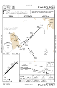
IAC chart of KSEZ
 Satellite view of KSEZ
Satellite view of KSEZ
Sorry, we have no imagery here.
Sorry, we have no imagery here.
Sorry, we have no imagery here.
Sorry, we have no imagery here.
Sorry, we have no imagery here.
Sorry, we have no imagery here.


KSEZ - Sedona
Located in Sedona, United States
ICAO - SEZ, IATA -
Data provided by AirmateGeneral information
Coordinates: N34°50'55" W111°47'18"
Elevation is 4830 feet MSL.
Magnetic variation is 13° East View others Airports in Arizona
Operational data
Special qualification required
Current time UTC:
Current local time:
Weather
METAR: KSEZ 290755Z AUTO 03009KT 10SM CLR 19/M10 A3006 RMK AO2
TAF: KSEZ 290527Z 2906/3006 03007G14KT P6SM BKN250 FM291500 VRB05KT P6SM BKN250 FM291900 19008G16KT P6SM SCT150 BKN200 FM300230 VRB05KT P6SM SCT150 BKN200
Communications frequencies: [VIEW]
Runways:
| RWY identifier | QFU | Length (ft) | Width (ft) | Surface | LDA (ft) |
| 03 | 45° | 5132 | 100 | ASPH | |
| 21 | 225° | 5132 | 100 | ASPH | |
| H1 | 0° | 0 | 0 | UNK |
Airport contact information
Address: Sedona United States
Satellite view of KSEZ
Sorry, we have no imagery here.
Sorry, we have no imagery here.
Sorry, we have no imagery here.
Sorry, we have no imagery here.
Sorry, we have no imagery here.
Sorry, we have no imagery here.