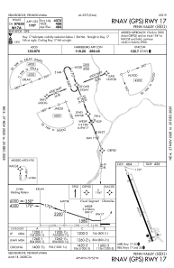
IAC chart of KSEG
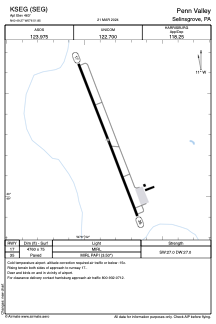
 ADC chart of KSEG
 Satellite view of KSEG
ADC chart of KSEG
Satellite view of KSEG
Sorry, we have no imagery here.
Sorry, we have no imagery here.
Sorry, we have no imagery here.
Sorry, we have no imagery here.
Sorry, we have no imagery here.
Sorry, we have no imagery here.


KSEG - Penn Valley
Located in Selinsgrove, United States
ICAO - SEG, IATA -
Data provided by AirmateGeneral information
Coordinates: N40°49'16" W76°51'51"
Elevation is 463 feet MSL.
Magnetic variation is -11° East View others Airports in Pennsylvania
Operational data
Special qualification required
Current time UTC:
Current local time:
Weather
METAR: KSEG 232353Z AUTO VRB04KT 10SM SCT060 BKN080 13/05 A2992 RMK AO2 SLP133 60001 T01280050 10167 20111 51021
Communications frequencies: [VIEW]
Runways:
| RWY identifier | QFU | Length (ft) | Width (ft) | Surface | LDA (ft) |
| 17 | 159° | 4760 | 75 | ASPH | |
| 35 | 339° | 4760 | 75 | ASPH |
Airport contact information
Address: Selinsgrove United States
Other aviation service providers
Flight schools

Satellite view of KSEG
Sorry, we have no imagery here.
Sorry, we have no imagery here.
Sorry, we have no imagery here.
Sorry, we have no imagery here.
Sorry, we have no imagery here.
Sorry, we have no imagery here.