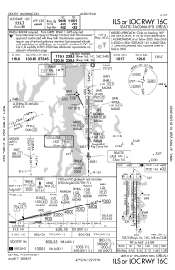
IAC chart of KSEA
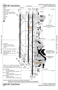
 ADC chart of KSEA
 Satellite view of KSEA
ADC chart of KSEA
Satellite view of KSEA
Sorry, we have no imagery here.
Sorry, we have no imagery here.
Sorry, we have no imagery here.
Sorry, we have no imagery here.
Sorry, we have no imagery here.
Sorry, we have no imagery here.


KSEA - Seattle-Tacoma Intl
Located in Seattle, United States
ICAO - SEA, IATA - SEA
Data provided by AirmateGeneral information
Coordinates: N47°26'60" W122°18'42"
Elevation is 432 feet MSL.
Magnetic variation is 16° East View others Airports in Washington
Operational data
Special qualification required
Current time UTC:
Current local time:
Weather
METAR: KSEA 301153Z 01009KT 10SM BKN200 05/04 A2984 RMK AO2 SLP111 T00500039 10078 20050 56026
TAF: KSEA 301123Z 3012/3118 04004KT P6SM BKN200 FM301400 05010KT P6SM BKN250 FM301900 07012G20KT P6SM BKN150 FM310030 11015G25KT P6SM -SHRA BKN060 FM310300 16007KT P6SM VCSH SCT025 OVC060
Communications frequencies: [VIEW]
Runways:
| RWY identifier | QFU | Length (ft) | Width (ft) | Surface | LDA (ft) |
| 16C | 180° | 9426 | 150 | CONC | 9426 |
| 34C | 0° | 9426 | 150 | CONC | 9426 |
| 16L | 180° | 11901 | 150 | CONC | 11901 |
| 34R | 0° | 11901 | 150 | CONC | 11901 |
| 16R | 180° | 8500 | 150 | CONC | 8500 |
| 34L | 0° | 8500 | 150 | CONC | 8500 |
Airport contact information
Address: Seattle United States
Satellite view of KSEA
Sorry, we have no imagery here.
Sorry, we have no imagery here.
Sorry, we have no imagery here.
Sorry, we have no imagery here.
Sorry, we have no imagery here.
Sorry, we have no imagery here.