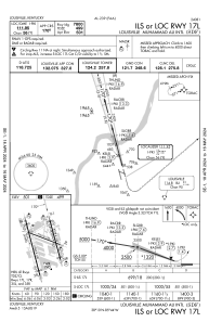
IAC chart of KSDF
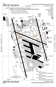
 ADC chart of KSDF
 Satellite view of KSDF
ADC chart of KSDF
Satellite view of KSDF
Sorry, we have no imagery here.
Sorry, we have no imagery here.
Sorry, we have no imagery here.
Sorry, we have no imagery here.
Sorry, we have no imagery here.
Sorry, we have no imagery here.


KSDF - Louisville Muhammad Ali Intl
Located in Louisville, United States
ICAO - SDF, IATA - SDF
Data provided by AirmateGeneral information
Coordinates: N38°10'27" W85°44'11"
Elevation is 500 feet MSL.
Magnetic variation is -05° East View others Airports in Kentucky
Operational data
Special qualification required
Current time UTC:
Current local time:
Weather
METAR: KSDF 291556Z 21015G25KT 10SM BKN150 OVC200 24/08 A3006 RMK AO2 PK WND 17032/1514 SLP173 T02390078
TAF: KSDF 291120Z 2912/3018 19010KT P6SM BKN150 WS020/22038KT FM291400 20014G24KT P6SM OVC150 FM292000 19012G22KT P6SM BKN080 FM300000 17010KT P6SM BKN050 FM300600 18011KT 6SM -SHRA BKN025 OVC040 FM301500 19013G21KT P6SM BKN025 OVC035
Communications frequencies: [VIEW]
Runways:
| RWY identifier | QFU | Length (ft) | Width (ft) | Surface | LDA (ft) |
| 11 | 111° | 7251 | 150 | CONC | 6946 |
| 29 | 291° | 7251 | 150 | CONC | 7250 |
| 17L | 165° | 8578 | 150 | CONC | 7800 |
| 35R | 345° | 8578 | 150 | CONC | 7800 |
| 17R | 165° | 11887 | 150 | CONC | 10000 |
| 35L | 345° | 11887 | 150 | CONC | 10000 |
Airport contact information
Address: Louisville United States
Other aviation service providers
Repair station

Satellite view of KSDF
Sorry, we have no imagery here.
Sorry, we have no imagery here.
Sorry, we have no imagery here.
Sorry, we have no imagery here.
Sorry, we have no imagery here.
Sorry, we have no imagery here.