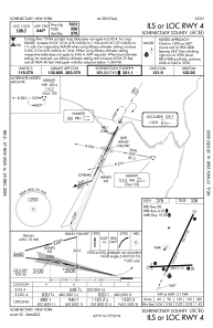
IAC chart of KSCH
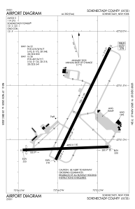
 ADC chart of KSCH
 Satellite view of KSCH
ADC chart of KSCH
Satellite view of KSCH
Sorry, we have no imagery here.
Sorry, we have no imagery here.
Sorry, we have no imagery here.
Sorry, we have no imagery here.
Sorry, we have no imagery here.
Sorry, we have no imagery here.


KSCH - Schenectady County
Located in Schenectady, United States
ICAO - SCH, IATA -
Data provided by AirmateGeneral information
Coordinates: N42°51'10" W73°55'46"
Elevation is 378 feet MSL.
Magnetic variation is -14° East View others Airports in New York
Operational data
Special qualification required
Current time UTC:
Current local time:
Weather
METAR: KSCH 162245Z 18014G27KT 10SM SCT034 OVC065 19/13 A2972
Communications frequencies: [VIEW]
Runways:
| RWY identifier | QFU | Length (ft) | Width (ft) | Surface | LDA (ft) |
| 04 | 26° | 7001 | 150 | ASPH | |
| 22 | 206° | 7001 | 150 | ASPH | |
| 10 | 88° | 4850 | 150 | ASPH | |
| 28 | 268° | 4850 | 150 | ASPH |
Airport contact information
Address: Schenectady United States
Other aviation service providers
Flight schools

Professional Flight Training, Inc.
Professional Flight Training, Inc.
info@aviationtrainingcenter.com5185738534
Satellite view of KSCH
Sorry, we have no imagery here.
Sorry, we have no imagery here.
Sorry, we have no imagery here.
Sorry, we have no imagery here.
Sorry, we have no imagery here.
Sorry, we have no imagery here.