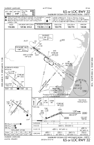
IAC chart of KSBY
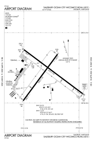
 ADC chart of KSBY
 Satellite view of KSBY
ADC chart of KSBY
Satellite view of KSBY
Sorry, we have no imagery here.
Sorry, we have no imagery here.
Sorry, we have no imagery here.
Sorry, we have no imagery here.
Sorry, we have no imagery here.
Sorry, we have no imagery here.


KSBY - Salisbury-Ocean City Wicomico Rgnl
Located in Salisbury, United States
ICAO - SBY, IATA - SBY
Data provided by AirmateGeneral information
Coordinates: N38°20'25" W75°30'34"
Elevation is 52 feet MSL.
Magnetic variation is -12° East View others Airports in Maryland
Operational data
Special qualification required
Current time UTC:
Current local time:
Weather
METAR: KSBY 241154Z 29012G19KT 10SM CLR 15/06 A3006 RMK AO2 SLP181 T01500061 10150 20083 51013
TAF: KSBY 241120Z 2412/2512 28008G14KT P6SM SKC FM241700 29015G24KT P6SM FEW150 FM250000 31006KT P6SM FEW060
Communications frequencies: [VIEW]
Runways:
| RWY identifier | QFU | Length (ft) | Width (ft) | Surface | LDA (ft) |
| 05 | 37° | 5000 | 100 | ASPH | 5000 |
| 23 | 217° | 5000 | 100 | ASPH | 5000 |
| 14 | 127° | 6400 | 100 | OTHER | 6400 |
| 32 | 307° | 6400 | 100 | OTHER | 6400 |
Airport contact information
Address: Salisbury United States
Other aviation service providers
Flight schools

Satellite view of KSBY
Sorry, we have no imagery here.
Sorry, we have no imagery here.
Sorry, we have no imagery here.
Sorry, we have no imagery here.
Sorry, we have no imagery here.
Sorry, we have no imagery here.