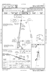
IAC chart of KSAW
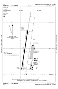
 ADC chart of KSAW
 Satellite view of KSAW

ADC chart of KSAW
Satellite view of KSAW
Sorry, we have no imagery here.
Sorry, we have no imagery here.
Sorry, we have no imagery here.
Sorry, we have no imagery here.
Sorry, we have no imagery here.
Sorry, we have no imagery here.


KSAW - Marquette/Sawyer Rgnl
Located in Marquette, United States
ICAO - SAW, IATA - MQT
Data provided by AirmateGeneral information
Coordinates: N46°20'57" W87°23'47"
Elevation is 1204 feet MSL.
Magnetic variation is -04° East View others Airports in Michigan
Operational data
Special qualification required
Current time UTC:
Current local time:
Weather
METAR: KSAW 180238Z AUTO 16008KT 10SM OVC100 01/M02 A2976 RMK AO2
TAF: KSAW 172320Z 1800/1824 18010G19KT P6SM BKN100 FM180600 32008KT P6SM SCT160 FM181200 01008KT 6SM BR BKN012 FM181900 04007KT P6SM BKN040
Communications frequencies: [VIEW]
Runways:
| RWY identifier | QFU | Length (ft) | Width (ft) | Surface | LDA (ft) |
| 01 | 9° | 9072 | 150 | ASPH | 9072 |
| 19 | 189° | 9072 | 150 | ASPH | 9072 |
Airport contact information
Address: Marquette United States
Satellite view of KSAW
Sorry, we have no imagery here.
Sorry, we have no imagery here.
Sorry, we have no imagery here.
Sorry, we have no imagery here.
Sorry, we have no imagery here.
Sorry, we have no imagery here.