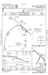
IAC chart of KRST
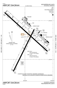
 ADC chart of KRST
 Satellite view of KRST

ADC chart of KRST
Satellite view of KRST
Sorry, we have no imagery here.
Sorry, we have no imagery here.
Sorry, we have no imagery here.
Sorry, we have no imagery here.
Sorry, we have no imagery here.
Sorry, we have no imagery here.


KRST - Rochester Intl
Located in Rochester, United States
ICAO - RST, IATA - RST
Data provided by AirmateGeneral information
Coordinates: N43°54'30" W92°30'0"
Elevation is 1317 feet MSL.
Magnetic variation is -01° East View others Airports in Minnesota
Operational data
Special qualification required
Current time UTC:
Current local time:
Weather
METAR: KRST 260454Z AUTO 14011KT 10SM OVC095 03/M01 A2973 RMK AO2 SLP081 T00331006
TAF: KRST 260523Z 2606/2706 14007KT P6SM SCT050 OVC060 FM260900 12007KT P6SM OVC035 FM261400 30008KT P6SM OVC010 FM262300 31012KT P6SM SCT015 BKN030
Communications frequencies: [VIEW]
Runways:
| RWY identifier | QFU | Length (ft) | Width (ft) | Surface | LDA (ft) |
| 03 | 26° | 7301 | 150 | OTHER | 7300 |
| 21 | 206° | 7301 | 150 | OTHER | 7300 |
| 13 | 132° | 9034 | 150 | CONC | 9033 |
| 31 | 312° | 9034 | 150 | CONC | 9033 |
Airport contact information
Address: Rochester United States
Other aviation service providers
Flight schools

Satellite view of KRST
Sorry, we have no imagery here.
Sorry, we have no imagery here.
Sorry, we have no imagery here.
Sorry, we have no imagery here.
Sorry, we have no imagery here.
Sorry, we have no imagery here.