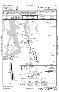
IAC chart of KRNT
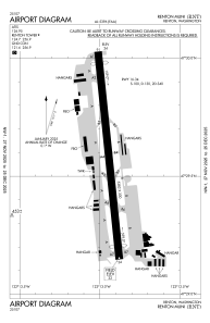
 ADC chart of KRNT
 Satellite view of KRNT
ADC chart of KRNT
Satellite view of KRNT
Sorry, we have no imagery here.
Sorry, we have no imagery here.
Sorry, we have no imagery here.
Sorry, we have no imagery here.
Sorry, we have no imagery here.
Sorry, we have no imagery here.


KRNT - Renton Muni
Located in Renton, United States
ICAO - RNT, IATA -
Data provided by AirmateGeneral information
Coordinates: N47°29'35" W122°12'57"
Elevation is 32 feet MSL.
Magnetic variation is 17° East View others Airports in Washington
Operational data
Special qualification required
Current time UTC:
Current local time:
Weather
METAR: KRNT 231153Z AUTO 00000KT 10SM OVC046 12/06 A3012 RMK AO2 SLP204 T01170061 10139 20111 53005
Communications frequencies: [VIEW]
Runways:
| RWY identifier | QFU | Length (ft) | Width (ft) | Surface | LDA (ft) |
| 16 | 174° | 5382 | 200 | OTHER | 4742 |
| 34 | 354° | 5382 | 200 | OTHER | 4742 |
Airport contact information
Address: Renton United States
Other aviation service providers
Repair station

Flight schools

Boeing Employees Flying Association
Boeing Employees Flying Association
befa_office@mindspring.com+1(425)237-2332
Satellite view of KRNT
Sorry, we have no imagery here.
Sorry, we have no imagery here.
Sorry, we have no imagery here.
Sorry, we have no imagery here.
Sorry, we have no imagery here.
Sorry, we have no imagery here.