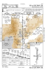
IAC chart of KRNO
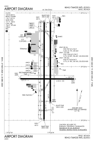
 ADC chart of KRNO
 Satellite view of KRNO
ADC chart of KRNO
Satellite view of KRNO
Sorry, we have no imagery here.
Sorry, we have no imagery here.
Sorry, we have no imagery here.
Sorry, we have no imagery here.
Sorry, we have no imagery here.
Sorry, we have no imagery here.


KRNO - Reno/Tahoe Intl
Located in Reno, United States
ICAO - RNO, IATA - RNO
Data provided by AirmateGeneral information
Coordinates: N39°29'57" W119°46'5"
Elevation is 4414 feet MSL.
Magnetic variation is 13° East View others Airports in Nevada
Operational data
Special qualification required
Current time UTC:
Current local time:
Weather
METAR: KRNO 231055Z 20003KT 10SM CLR 09/M06 A3001 RMK AO2 SLP121 T00941061
TAF: KRNO 230538Z 2306/2406 28009KT P6SM FEW200 FM230700 VRB04KT P6SM BKN200 FM232100 28010G18KT P6SM FEW120 FEW200 FM240300 31011KT P6SM SKC
Communications frequencies: [VIEW]
Runways:
| RWY identifier | QFU | Length (ft) | Width (ft) | Surface | LDA (ft) |
| 08 | 90° | 6102 | 150 | CONC | 5854 |
| 26 | 270° | 6102 | 150 | CONC | 6102 |
| 17L | 180° | 9000 | 150 | CONC | 9000 |
| 35R | 0° | 9000 | 150 | CONC | 9000 |
| 17R | 180° | 11001 | 150 | CONC | 10001 |
| 35L | 0° | 11001 | 150 | CONC | 10011 |
Airport contact information
Address: Reno United States
Other aviation service providers
Flight schools

Satellite view of KRNO
Sorry, we have no imagery here.
Sorry, we have no imagery here.
Sorry, we have no imagery here.
Sorry, we have no imagery here.
Sorry, we have no imagery here.
Sorry, we have no imagery here.