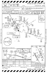
IAC chart of KRND
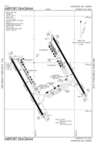
 ADC chart of KRND
 Satellite view of KRND
ADC chart of KRND
Satellite view of KRND
Sorry, we have no imagery here.
Sorry, we have no imagery here.
Sorry, we have no imagery here.
Sorry, we have no imagery here.
Sorry, we have no imagery here.
Sorry, we have no imagery here.


KRND - Randolph Afb
Located in Universal City, United States
ICAO - RND, IATA -
Data provided by AirmateGeneral information
Coordinates: N29°31'44" W98°16'41"
Elevation is 760 feet MSL.
Magnetic variation is 05° East View others Airports in Texas
Operational data
Special qualification required
Current time UTC:
Current local time:
Weather
METAR: KRND 162305Z AUTO 32013KT 10SM CLR 27/M16 A3007 RMK AO2 WSHFT 2255 PRESRR SLP179 $
Communications frequencies: [VIEW]
Runways:
| RWY identifier | QFU | Length (ft) | Width (ft) | Surface | LDA (ft) |
| 15L | 0° | 8351 | 200 | CONC | |
| 33R | 0° | 8351 | 200 | CONC | |
| 15R | 0° | 8352 | 200 | OTHER | |
| 33L | 0° | 8352 | 200 | OTHER |
Airport contact information
Address: Universal City United States
Satellite view of KRND
Sorry, we have no imagery here.
Sorry, we have no imagery here.
Sorry, we have no imagery here.
Sorry, we have no imagery here.
Sorry, we have no imagery here.
Sorry, we have no imagery here.