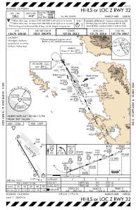
IAC chart of KRIV
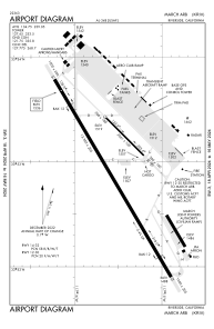
 ADC chart of KRIV
 Satellite view of KRIV
ADC chart of KRIV
Satellite view of KRIV
Sorry, we have no imagery here.
Sorry, we have no imagery here.
Sorry, we have no imagery here.
Sorry, we have no imagery here.
Sorry, we have no imagery here.
Sorry, we have no imagery here.


KRIV - March Arb
Located in Riverside, United States
ICAO - RIV, IATA -
Data provided by AirmateGeneral information
Coordinates: N33°52'55" W117°15'32"
Elevation is 1536 feet MSL.
Magnetic variation is 14° East View others Airports in California
Operational data
Special qualification required
Current time UTC:
Current local time:
Weather
METAR: KRIV 180855Z AUTO 33004KT 10SM OVC040 12/08 A2996 RMK AO2 SLP142 T01150082 50000
TAF: TAF KRIV 180404Z 1804/1910 32006KT 9999 FEW015 SCT022 OVC045 510509 QNH2995INS BECMG 1806/1807 16006KT 9999 VCSH SCT015 OVC020 510509 QNH2993INS TEMPO 1807/1815 9000 -RA BR BKN015 OVC020 BECMG 1816/1817 31009KT 9999 VCSH BKN025 BKN040 510708 QNH2995INS BECMG 1821/1822 32009KT 9999 NSW BKN030 BKN050 510009 QNH2994INS TEMPO 1822/1902 32010G15KT BECMG 1902/1903 30006KT 9999 BKN015 OVC025 510309 QNH2998INS BECMG 1905/1906 30004KT 8000 BR OVC007 510309 QNH3003INS BECMG 1908/1909 30004KT 3200 BR OVC003 510309 QNH3004INS TX16/1822Z TN09/1813Z
Communications frequencies: [VIEW]
Runways:
| RWY identifier | QFU | Length (ft) | Width (ft) | Surface | LDA (ft) |
| 12 | 135° | 3061 | 100 | ASPH | |
| 30 | 315° | 3061 | 100 | ASPH | |
| 14 | 149° | 13302 | 200 | CONC | |
| 32 | 329° | 13302 | 200 | CONC |
Airport contact information
Address: Riverside United States
Satellite view of KRIV
Sorry, we have no imagery here.
Sorry, we have no imagery here.
Sorry, we have no imagery here.
Sorry, we have no imagery here.
Sorry, we have no imagery here.
Sorry, we have no imagery here.