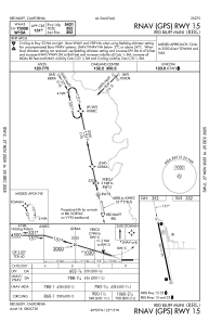
IAC chart of KRBL
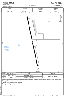
 ADC chart of KRBL
 Satellite view of KRBL
ADC chart of KRBL
Satellite view of KRBL
Sorry, we have no imagery here.
Sorry, we have no imagery here.
Sorry, we have no imagery here.
Sorry, we have no imagery here.
Sorry, we have no imagery here.
Sorry, we have no imagery here.


KRBL - Red Bluff Muni
Located in Red Bluff, United States
ICAO - RBL, IATA -
Data provided by AirmateGeneral information
Coordinates: N40°9'1" W122°15'8"
Elevation is 352 feet MSL.
Magnetic variation is 17° East View others Airports in California
Operational data
Special qualification required
Current time UTC:
Current local time:
Weather
METAR: KRBL 210754Z AUTO 32006KT 10SM CLR 18/03 A2998 RMK AO2 SLP148 T01830028 403110122 $
TAF: KRBL 210522Z 2106/2206 VRB06KT P6SM SKC FM211400 35011KT P6SM SKC FM212100 16005KT P6SM FEW250
Communications frequencies: [VIEW]
Runways:
| RWY identifier | QFU | Length (ft) | Width (ft) | Surface | LDA (ft) |
| 15 | 168° | 5431 | 100 | ASPH | |
| 33 | 348° | 5431 | 100 | ASPH | |
| H1 | 0° | 0 | 0 | UNK |
Airport contact information
Address: Red Bluff United States
Satellite view of KRBL
Sorry, we have no imagery here.
Sorry, we have no imagery here.
Sorry, we have no imagery here.
Sorry, we have no imagery here.
Sorry, we have no imagery here.
Sorry, we have no imagery here.