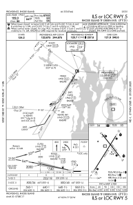
IAC chart of KPVD
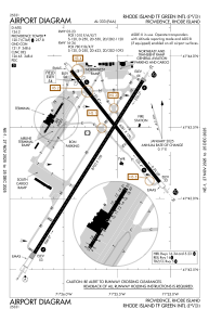
 ADC chart of KPVD
 Satellite view of KPVD
ADC chart of KPVD
Satellite view of KPVD
Sorry, we have no imagery here.
Sorry, we have no imagery here.
Sorry, we have no imagery here.
Sorry, we have no imagery here.
Sorry, we have no imagery here.
Sorry, we have no imagery here.


KPVD - Rhode Island Tf Green Intl
Located in Providence, United States
ICAO - PVD, IATA - PVD
Data provided by AirmateGeneral information
Coordinates: N41°43'20" W71°25'40"
Elevation is 54 feet MSL.
Magnetic variation is -15° East View others Airports in Rhode Island
Operational data
Special qualification required
Current time UTC:
Current local time:
Weather
METAR: KPVD 311051Z 19008KT 4SM BR OVC006 11/11 A2985 RMK AO2 SLP109 T01060106
TAF: KPVD 310903Z 3109/0106 21004KT 1/4SM FG VCSH VV002 WS020/22040KT FM311600 21014G23KT 3SM BR VCSH OVC003 WS020/22045KT FM010000 20010G20KT 1SM BR VCSH OVC003 WS020/23045KT FM010300 22012G20KT 3SM +SHRA BR OVC003
Communications frequencies: [VIEW]
Runways:
| RWY identifier | QFU | Length (ft) | Width (ft) | Surface | LDA (ft) |
| 05 | 32° | 8700 | 150 | ASPH | 8700 |
| 23 | 212° | 8700 | 150 | ASPH | 8700 |
| 16 | 142° | 6081 | 150 | ASPH | 5516 |
| 34 | 322° | 6081 | 150 | ASPH | 6081 |
Airport contact information
Address: Providence United States
Handlers

Other aviation service providers
Flight schools

Satellite view of KPVD
Sorry, we have no imagery here.
Sorry, we have no imagery here.
Sorry, we have no imagery here.
Sorry, we have no imagery here.
Sorry, we have no imagery here.
Sorry, we have no imagery here.