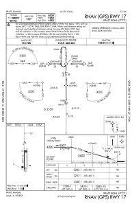
IAC chart of KPTT
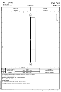
 ADC chart of KPTT
 Satellite view of KPTT
ADC chart of KPTT
Satellite view of KPTT
Sorry, we have no imagery here.
Sorry, we have no imagery here.
Sorry, we have no imagery here.
Sorry, we have no imagery here.
Sorry, we have no imagery here.
Sorry, we have no imagery here.


KPTT - Pratt Rgnl
Located in Pratt, United States
ICAO - PTT, IATA -
Data provided by AirmateGeneral information
Coordinates: N37°42'9" W98°44'49"
Elevation is 1952 feet MSL.
Magnetic variation is 07° East View others Airports in Kansas
Operational data
Special qualification required
Current time UTC:
Current local time:
Weather
METAR: KPTT 190835Z AUTO 19019G24KT 10SM SCT016 BKN021 BKN028 22/22 A2955 RMK AO2 T02170215
Communications frequencies: [VIEW]
Runways:
| RWY identifier | QFU | Length (ft) | Width (ft) | Surface | LDA (ft) |
| 17 | 180° | 5500 | 100 | CONC | |
| 35 | 0° | 5500 | 100 | CONC |
Airport contact information
Address: Pratt United States
Satellite view of KPTT
Sorry, we have no imagery here.
Sorry, we have no imagery here.
Sorry, we have no imagery here.
Sorry, we have no imagery here.
Sorry, we have no imagery here.
Sorry, we have no imagery here.