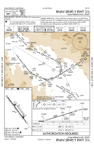
IAC chart of KPSP
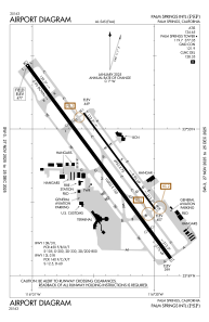
 ADC chart of KPSP
 Satellite view of KPSP
ADC chart of KPSP
Satellite view of KPSP
Sorry, we have no imagery here.
Sorry, we have no imagery here.
Sorry, we have no imagery here.
Sorry, we have no imagery here.
Sorry, we have no imagery here.
Sorry, we have no imagery here.


KPSP - Palm Springs Intl
Located in Palm Springs, United States
ICAO - PSP, IATA - PSP
Data provided by AirmateGeneral information
Coordinates: N33°49'47" W116°30'24"
Elevation is 476 feet MSL.
Magnetic variation is 13° East View others Airports in California
Operational data
Special qualification required
Current time UTC:
Current local time:
Weather
METAR: KPSP 181353Z 16004KT 10SM CLR 18/08 A2985 RMK AO2 SLP106 T01830078
TAF: KPSP 181120Z 1812/1912 31008KT P6SM SKC FM181800 32012G20KT P6SM SKC FM190800 32008KT P6SM FEW250
Communications frequencies: [VIEW]
Runways:
| RWY identifier | QFU | Length (ft) | Width (ft) | Surface | LDA (ft) |
| 13L | 143° | 4953 | 75 | ASPH | 4953 |
| 31R | 323° | 4953 | 75 | ASPH | 4953 |
| 13R | 143° | 10000 | 150 | ASPH | 6857 |
| 31L | 323° | 10000 | 150 | ASPH | 8500 |
Airport contact information
Address: Palm Springs United States
Other aviation service providers
Repair station

Flight schools

Palm Springs Aviators - Flying Club
Palm Springs Aviators - Flying Club
brian@palmspringsaviators.com+1(760)348-8748
Satellite view of KPSP
Sorry, we have no imagery here.
Sorry, we have no imagery here.
Sorry, we have no imagery here.
Sorry, we have no imagery here.
Sorry, we have no imagery here.
Sorry, we have no imagery here.