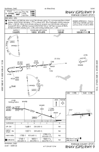
IAC chart of KPOV
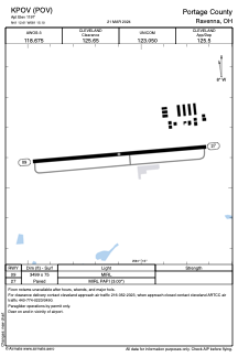
 ADC chart of KPOV
 Satellite view of KPOV
ADC chart of KPOV
Satellite view of KPOV
Sorry, we have no imagery here.
Sorry, we have no imagery here.
Sorry, we have no imagery here.
Sorry, we have no imagery here.
Sorry, we have no imagery here.
Sorry, we have no imagery here.


KPOV - Portage County
Located in Ravenna, United States
ICAO - POV, IATA -
Data provided by AirmateGeneral information
Coordinates: N41°12'37" W81°15'6"
Elevation is 1197 feet MSL.
Magnetic variation is -08° East View others Airports in Ohio
Operational data
Special qualification required
Current time UTC:
Current local time:
Weather
METAR: KPOV 292055Z AUTO 26004KT 10SM CLR 20/09 A2998 RMK AO2 T02030088 PWINO
Communications frequencies: [VIEW]
Runways:
| RWY identifier | QFU | Length (ft) | Width (ft) | Surface | LDA (ft) |
| 09 | 85° | 3499 | 75 | ASPH | |
| 27 | 265° | 3499 | 75 | ASPH |
Airport contact information
Address: Ravenna United States
Satellite view of KPOV
Sorry, we have no imagery here.
Sorry, we have no imagery here.
Sorry, we have no imagery here.
Sorry, we have no imagery here.
Sorry, we have no imagery here.
Sorry, we have no imagery here.