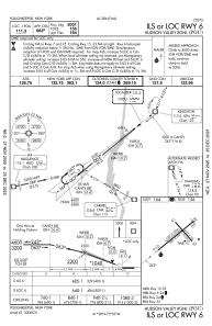
IAC chart of KPOU
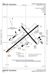
 ADC chart of KPOU
 Satellite view of KPOU
ADC chart of KPOU
Satellite view of KPOU
Sorry, we have no imagery here.
Sorry, we have no imagery here.
Sorry, we have no imagery here.
Sorry, we have no imagery here.
Sorry, we have no imagery here.
Sorry, we have no imagery here.


KPOU - Hudson Valley Rgnl
Located in Poughkeepsie, United States
ICAO - POU, IATA - POU
Data provided by AirmateGeneral information
Coordinates: N41°37'36" W73°53'3"
Elevation is 163 feet MSL.
Magnetic variation is -12° East View others Airports in New York
Operational data
Special qualification required
Current time UTC:
Current local time:
Weather
METAR: KPOU 192153Z 01010G21KT 10SM CLR 18/05 A2979 RMK AO2 SLP083 T01780050
TAF: KPOU 191721Z 1918/2018 33015G25KT P6SM FEW050 FM200100 34009KT P6SM FEW040 FM201200 35009G15KT P6SM BKN040
Communications frequencies: [VIEW]
Runways:
| RWY identifier | QFU | Length (ft) | Width (ft) | Surface | LDA (ft) |
| 06 | 51° | 5001 | 100 | ASPH | 5001 |
| 24 | 231° | 5001 | 100 | ASPH | 4886 |
| 07 | 51° | 1357 | 100 | GRASS | |
| 25 | 231° | 1357 | 100 | GRASS | |
| 15 | 139° | 2743 | 100 | OTHER | 2743 |
| 33 | 319° | 2743 | 100 | OTHER | 2743 |
Airport contact information
Address: Poughkeepsie United States
Satellite view of KPOU
Sorry, we have no imagery here.
Sorry, we have no imagery here.
Sorry, we have no imagery here.
Sorry, we have no imagery here.
Sorry, we have no imagery here.
Sorry, we have no imagery here.