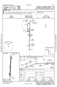
IAC chart of KPOF
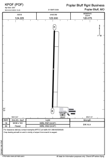
 ADC chart of KPOF
 Satellite view of KPOF

ADC chart of KPOF
Satellite view of KPOF
Sorry, we have no imagery here.
Sorry, we have no imagery here.
Sorry, we have no imagery here.
Sorry, we have no imagery here.
Sorry, we have no imagery here.
Sorry, we have no imagery here.


KPOF - Poplar Bluff Rgnl Business
Located in Poplar Bluff, United States
ICAO - POF, IATA -
Data provided by AirmateGeneral information
Coordinates: N36°46'26" W90°19'29"
Elevation is 330 feet MSL.
Magnetic variation is -00° East View others Airports in Missouri
Operational data
Special qualification required
Current time UTC:
Current local time:
Weather
METAR: KPOF 080553Z AUTO 31010KT 10SM CLR 12/03 A2987 RMK AO2 SLP115 T01220028 10156 20122 401720044 51036
Communications frequencies: [VIEW]
Runways:
| RWY identifier | QFU | Length (ft) | Width (ft) | Surface | LDA (ft) |
| 18 | 181° | 5008 | 100 | CONC | |
| 36 | 1° | 5008 | 100 | CONC |
Airport contact information
Address: Poplar Bluff United States
Satellite view of KPOF
Sorry, we have no imagery here.
Sorry, we have no imagery here.
Sorry, we have no imagery here.
Sorry, we have no imagery here.
Sorry, we have no imagery here.
Sorry, we have no imagery here.