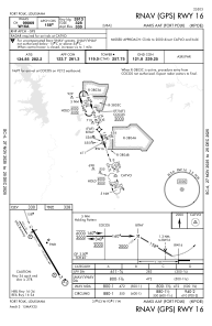
IAC chart of KPOE
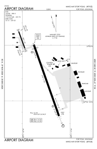
 ADC chart of KPOE
 Satellite view of KPOE
ADC chart of KPOE
Satellite view of KPOE
Sorry, we have no imagery here.
Sorry, we have no imagery here.
Sorry, we have no imagery here.
Sorry, we have no imagery here.
Sorry, we have no imagery here.
Sorry, we have no imagery here.


KPOE - Maks Aaf
Located in Fort Johnson, United States
ICAO - POE, IATA -
Data provided by AirmateGeneral information
Coordinates: N31°2'41" W93°11'30"
Elevation is 330 feet MSL.
Magnetic variation is 02° East View others Airports in Louisiana
Operational data
Special qualification required
Current time UTC:
Current local time:
Weather
METAR: KPOE 190155Z AUTO 15008KT 10SM BKN190 26/22 A2982 RMK AO2 SLP097 T02630223
TAF: TAF KPOE 182300Z 1823/2005 19012KT 9999 SCT020 QNH2985INS BECMG 1906/1907 16009KT 9999 OVC010 QNH2980INS BECMG 1915/1916 19012G20KT 9999 SCT040 QNH2981INS TEMPO 1917/1922 19015G25KT BECMG 1923/1924 16009KT 9999 SCT030 QNH2981INS TX34/1321Z TN24/1908Z
Communications frequencies: [VIEW]
Runways:
| RWY identifier | QFU | Length (ft) | Width (ft) | Surface | LDA (ft) |
| 16 | 160° | 4107 | 100 | ASPH | |
| 34 | 340° | 4107 | 100 | ASPH |
Airport contact information
Address: Fort Johnson United States
Satellite view of KPOE
Sorry, we have no imagery here.
Sorry, we have no imagery here.
Sorry, we have no imagery here.
Sorry, we have no imagery here.
Sorry, we have no imagery here.
Sorry, we have no imagery here.