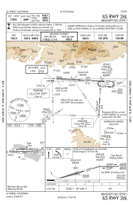
IAC chart of KPOC
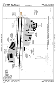
 ADC chart of KPOC
 Satellite view of KPOC

ADC chart of KPOC
Satellite view of KPOC
Sorry, we have no imagery here.
Sorry, we have no imagery here.
Sorry, we have no imagery here.
Sorry, we have no imagery here.
Sorry, we have no imagery here.
Sorry, we have no imagery here.


KPOC - Brackett Fld
Located in La Verne, United States
ICAO - POC, IATA -
Data provided by AirmateGeneral information
Coordinates: N34°5'30" W117°46'54"
Elevation is 1013 feet MSL.
Magnetic variation is 14° East View others Airports in California
Operational data
Special qualification required
Current time UTC:
Current local time:
Weather
METAR: KPOC 180147Z 24010KT 4SM BR OVC014 12/12 A3005
Communications frequencies: [VIEW]
Runways:
| RWY identifier | QFU | Length (ft) | Width (ft) | Surface | LDA (ft) |
| 08L | 93° | 3661 | 75 | ASPH | |
| 26R | 273° | 3661 | 75 | ASPH | |
| 08R | 93° | 4840 | 75 | ASPH | |
| 26L | 273° | 4840 | 75 | ASPH |
Airport contact information
Address: La Verne United States
Other aviation service providers
Flight schools

Satellite view of KPOC
Sorry, we have no imagery here.
Sorry, we have no imagery here.
Sorry, we have no imagery here.
Sorry, we have no imagery here.
Sorry, we have no imagery here.
Sorry, we have no imagery here.