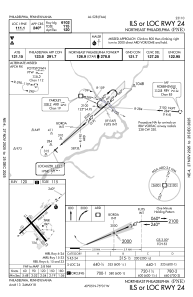
IAC chart of KPNE
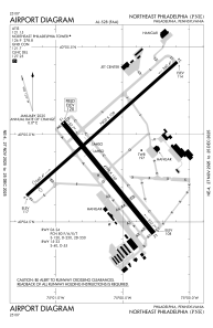
 ADC chart of KPNE
 Satellite view of KPNE
ADC chart of KPNE
Satellite view of KPNE
Sorry, we have no imagery here.
Sorry, we have no imagery here.
Sorry, we have no imagery here.
Sorry, we have no imagery here.
Sorry, we have no imagery here.
Sorry, we have no imagery here.


KPNE - Northeast Philadelphia
Located in Philadelphia, United States
ICAO - PNE, IATA -
Data provided by AirmateGeneral information
Coordinates: N40°4'55" W75°0'38"
Elevation is 119 feet MSL.
Magnetic variation is -12° East View others Airports in Pennsylvania
Operational data
Special qualification required
Current time UTC:
Current local time:
Weather
METAR: KPNE 201254Z 36012KT 10SM CLR 12/03 A3000 RMK AO2 SLP157 T01220033
TAF: KPNE 201120Z 2012/2112 34008KT P6SM SKC FM201500 35009KT P6SM FEW080 SCT250 FM202200 03005KT P6SM BKN150 FM210100 09004KT P6SM BKN080 FM210700 10005KT P6SM OVC050 FM210900 10006KT P6SM VCSH OVC020
Communications frequencies: [VIEW]
Runways:
| RWY identifier | QFU | Length (ft) | Width (ft) | Surface | LDA (ft) |
| 06 | 48° | 7000 | 100 | ASPH | 6502 |
| 24 | 228° | 7000 | 100 | ASPH | 6102 |
| 15 | 141° | 4999 | 150 | ASPH | |
| 33 | 321° | 4999 | 150 | ASPH |
Airport contact information
Address: Philadelphia United States
Other aviation service providers
Flight schools

Satellite view of KPNE
Sorry, we have no imagery here.
Sorry, we have no imagery here.
Sorry, we have no imagery here.
Sorry, we have no imagery here.
Sorry, we have no imagery here.
Sorry, we have no imagery here.