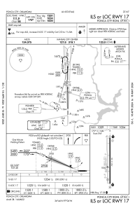
IAC chart of KPNC
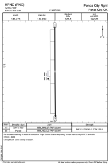
 ADC chart of KPNC
 Satellite view of KPNC
ADC chart of KPNC
Satellite view of KPNC
Sorry, we have no imagery here.
Sorry, we have no imagery here.
Sorry, we have no imagery here.
Sorry, we have no imagery here.
Sorry, we have no imagery here.
Sorry, we have no imagery here.


KPNC - Ponca City Rgnl
Located in Ponca City, United States
ICAO - PNC, IATA -
Data provided by AirmateGeneral information
Coordinates: N36°43'55" W97°5'59"
Elevation is 1008 feet MSL.
Magnetic variation is 05° East View others Airports in Oklahoma
Operational data
Special qualification required
Current time UTC:
Current local time:
Weather
TAF: KPNC 221720Z 2218/2318 17014G21KT P6SM FEW150 FM230800 22010KT P6SM SKC FM231000 31015G24KT P6SM BKN250
Communications frequencies: [VIEW]
Runways:
| RWY identifier | QFU | Length (ft) | Width (ft) | Surface | LDA (ft) |
| 17 | 180° | 7201 | 100 | CONC | |
| 35 | 360° | 7201 | 100 | CONC |
Airport contact information
Address: Ponca City United States
Satellite view of KPNC
Sorry, we have no imagery here.
Sorry, we have no imagery here.
Sorry, we have no imagery here.
Sorry, we have no imagery here.
Sorry, we have no imagery here.
Sorry, we have no imagery here.