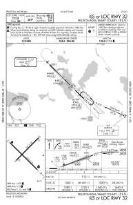
IAC chart of KPLN
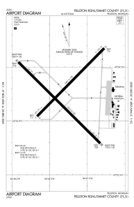
 ADC chart of KPLN
 Satellite view of KPLN

ADC chart of KPLN
Satellite view of KPLN
Sorry, we have no imagery here.
Sorry, we have no imagery here.
Sorry, we have no imagery here.
Sorry, we have no imagery here.
Sorry, we have no imagery here.
Sorry, we have no imagery here.


KPLN - Pellston Rgnl/Emmet County
Located in Pellston, United States
ICAO - PLN, IATA - PLN
Data provided by AirmateGeneral information
Coordinates: N45°34'15" W84°47'48"
Elevation is 720 feet MSL.
Magnetic variation is -06° East View others Airports in Michigan
Operational data
Special qualification required
Current time UTC:
Current local time:
Weather
METAR: KPLN 171754Z AUTO 14010KT 10SM CLR 02/M07 A3008 RMK AO2 SLP196 T00221067 10022 21139 58022
TAF: KPLN 171737Z 1718/1818 14009KT P6SM FEW250 FM180300 21007KT P6SM BKN100 WS020/25040KT FM181000 26006KT P6SM SCT200
Communications frequencies: [VIEW]
Runways:
| RWY identifier | QFU | Length (ft) | Width (ft) | Surface | LDA (ft) |
| 05 | 45° | 5401 | 150 | ASPH | 5395 |
| 23 | 225° | 5401 | 150 | ASPH | 5395 |
| 14 | 135° | 6513 | 150 | ASPH | 6512 |
| 32 | 315° | 6513 | 150 | ASPH | 6513 |
Airport contact information
Address: Pellston United States
Satellite view of KPLN
Sorry, we have no imagery here.
Sorry, we have no imagery here.
Sorry, we have no imagery here.
Sorry, we have no imagery here.
Sorry, we have no imagery here.
Sorry, we have no imagery here.