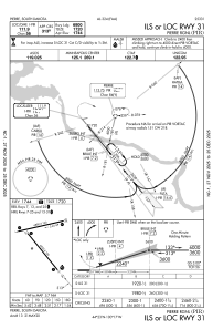
IAC chart of KPIR
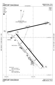
 ADC chart of KPIR
 Satellite view of KPIR

ADC chart of KPIR
Satellite view of KPIR
Sorry, we have no imagery here.
Sorry, we have no imagery here.
Sorry, we have no imagery here.
Sorry, we have no imagery here.
Sorry, we have no imagery here.
Sorry, we have no imagery here.


KPIR - Pierre Rgnl
Located in Pierre, United States
ICAO - PIR, IATA - PIR
Data provided by AirmateGeneral information
Coordinates: N44°22'58" W100°17'10"
Elevation is 1744 feet MSL.
Magnetic variation is 08° East View others Airports in South Dakota
Operational data
Special qualification required
Current time UTC:
Current local time:
Weather
METAR: KPIR 150753Z AUTO 33018G30KT 10SM OVC060 M02/M06 A2939 RMK AO2 PK WND 34038/0713 UPE11 SLP958 P0000 T10221056 $
TAF: KPIR 150712Z 1507/1606 33030G38KT P6SM VCSH OVC050 FM150900 32028G37KT P6SM OVC100 FM151900 32019G28KT P6SM SKC FM160000 36008KT P6SM SKC
Communications frequencies: [VIEW]
Runways:
| RWY identifier | QFU | Length (ft) | Width (ft) | Surface | LDA (ft) |
| 07 | 77° | 6880 | 100 | ASPH | 6830 |
| 25 | 257° | 6880 | 100 | ASPH | 6880 |
| 13 | 141° | 6900 | 100 | ASPH | 6900 |
| 31 | 321° | 6900 | 100 | ASPH | 6900 |
Airport contact information
Address: Pierre United States
Other aviation service providers
Flight schools

Satellite view of KPIR
Sorry, we have no imagery here.
Sorry, we have no imagery here.
Sorry, we have no imagery here.
Sorry, we have no imagery here.
Sorry, we have no imagery here.
Sorry, we have no imagery here.