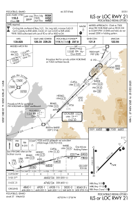
IAC chart of KPIH
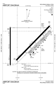
 ADC chart of KPIH
 Satellite view of KPIH
ADC chart of KPIH
Satellite view of KPIH
Sorry, we have no imagery here.
Sorry, we have no imagery here.
Sorry, we have no imagery here.
Sorry, we have no imagery here.
Sorry, we have no imagery here.
Sorry, we have no imagery here.


KPIH - Pocatello Rgnl
Located in Pocatello, United States
ICAO - PIH, IATA - PIH
Data provided by AirmateGeneral information
Coordinates: N42°54'35" W112°35'45"
Elevation is 4451 feet MSL.
Magnetic variation is 14° East View others Airports in Idaho
Operational data
Special qualification required
Current time UTC:
Current local time:
Weather
METAR: KPIH 171753Z 24013KT 10SM SCT020 BKN060 06/00 A2989 RMK AO2 SLP111 T00560000 10072 20033 57003
TAF: KPIH 171721Z 1718/1818 24015KT P6SM VCSH OVC050 FM172300 24010KT 6SM -RA SCT015 OVC025 FM180300 25010KT 1SM -SN BR OVC015 FM181200 27020G30KT 6SM -SN OVC025
Communications frequencies: [VIEW]
Runways:
| RWY identifier | QFU | Length (ft) | Width (ft) | Surface | LDA (ft) |
| 03 | 45° | 9059 | 150 | ASPH | 9059 |
| 21 | 225° | 9059 | 150 | ASPH | 9059 |
| 17 | 180° | 7150 | 100 | ASPH | 7150 |
| 35 | 360° | 7150 | 100 | ASPH | 7150 |
Airport contact information
Address: Pocatello United States
Other aviation service providers
Flight schools

Satellite view of KPIH
Sorry, we have no imagery here.
Sorry, we have no imagery here.
Sorry, we have no imagery here.
Sorry, we have no imagery here.
Sorry, we have no imagery here.
Sorry, we have no imagery here.