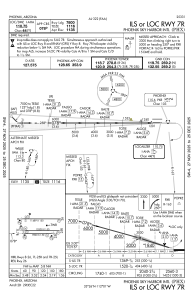
IAC chart of KPHX
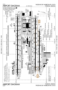
 ADC chart of KPHX
 Satellite view of KPHX
ADC chart of KPHX
Satellite view of KPHX
Sorry, we have no imagery here.
Sorry, we have no imagery here.
Sorry, we have no imagery here.
Sorry, we have no imagery here.
Sorry, we have no imagery here.
Sorry, we have no imagery here.


KPHX - Phoenix Sky Harbor Intl
Located in Phoenix, United States
ICAO - PHX, IATA - PHX
Data provided by AirmateGeneral information
Coordinates: N33°26'3" W112°0'42"
Elevation is 1134 feet MSL.
Magnetic variation is 12° East View others Airports in Arizona
Operational data
Special qualification required
Current time UTC:
Current local time:
Weather
METAR: KPHX 192051Z 28017G28KT 10SM CLR 33/M07 A2980 RMK AO2 PK WND 28031/2007 SLP075 T03331067 58019
Communications frequencies: [VIEW]
Runways:
| RWY identifier | QFU | Length (ft) | Width (ft) | Surface | LDA (ft) |
| 07L | 90° | 10300 | 150 | CONC | 10300 |
| 25R | 270° | 10300 | 150 | CONC | 10300 |
| 07R | 90° | 7800 | 150 | CONC | 7800 |
| 25L | 270° | 7800 | 150 | CONC | 7800 |
| 08 | 90° | 11489 | 150 | CONC | 10591 |
| 26 | 270° | 11489 | 150 | CONC | 11489 |
Airport contact information
Address: Phoenix United States
Other aviation service providers
Repair station

Satellite view of KPHX
Sorry, we have no imagery here.
Sorry, we have no imagery here.
Sorry, we have no imagery here.
Sorry, we have no imagery here.
Sorry, we have no imagery here.
Sorry, we have no imagery here.