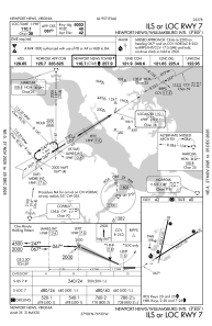
IAC chart of KPHF
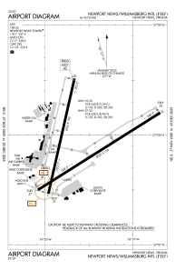
 ADC chart of KPHF
 Satellite view of KPHF
ADC chart of KPHF
Satellite view of KPHF
Sorry, we have no imagery here.
Sorry, we have no imagery here.
Sorry, we have no imagery here.
Sorry, we have no imagery here.
Sorry, we have no imagery here.
Sorry, we have no imagery here.


KPHF - Newport News/Williamsburg Intl
Located in Newport News, United States
ICAO - PHF, IATA - PHF
Data provided by AirmateGeneral information
Coordinates: N37°7'55" W76°29'35"
Elevation is 42 feet MSL.
Magnetic variation is -09° East View others Airports in Virginia
Operational data
Special qualification required
Current time UTC:
Current local time:
Weather
METAR: KPHF 180454Z AUTO 33013G21KT 10SM CLR 06/M03 A3005 RMK AO2 PK WND 34026/0437 SLP176 T00611028 401830061
TAF: KPHF 180537Z 1806/1906 34012G20KT P6SM SKC FM181900 33008KT P6SM SKC
Communications frequencies: [VIEW]
Runways:
| RWY identifier | QFU | Length (ft) | Width (ft) | Surface | LDA (ft) |
| 02 | 13° | 6526 | 150 | CONC | 6526 |
| 20 | 193° | 6526 | 150 | CONC | 6526 |
| 07 | 58° | 8003 | 150 | ASPH | 8003 |
| 25 | 238° | 8003 | 150 | ASPH | 8003 |
Airport contact information
Address: Newport News United States
Other aviation service providers
Flight schools

Satellite view of KPHF
Sorry, we have no imagery here.
Sorry, we have no imagery here.
Sorry, we have no imagery here.
Sorry, we have no imagery here.
Sorry, we have no imagery here.
Sorry, we have no imagery here.