IAC chart of KPAM
 ADC chart of KPAM
 Satellite view of KPAM
ADC chart of KPAM
Satellite view of KPAM
Sorry, we have no imagery here.
Sorry, we have no imagery here.
Sorry, we have no imagery here.
Sorry, we have no imagery here.
Sorry, we have no imagery here.
Sorry, we have no imagery here.


KPAM - Tyndall Afb
Located in Panama City, United States
ICAO - PAM, IATA - PAM
Data provided by AirmateGeneral information
Coordinates: N30°4'9" W85°34'30"
Elevation is 17 feet MSL.
Magnetic variation is -04° East View others Airports in Florida
Operational data
Special qualification required
Current time UTC:
Current local time:
Weather
METAR: KPAM 171855Z 23009KT 10SM FEW015 SCT170 29/24 A3001 RMK AO2A SLP165 T02850240
TAF: TAF KPAM 171900Z 1719/1901 24010G18KT 9999 SCT010 SCT025 QNH2995INS BECMG 1802/1803 23006KT 9999 BKN010 QNH2996INS TEMPO 1808/1812 VRB06KT 3200 BR BKN003 BECMG 1813/1814 23009KT 9999 SCT010 BKN025 QNH2995INS TX29/1719Z TN24/1811Z
Communications frequencies: [VIEW]
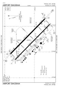
Runways:
| RWY identifier | QFU | Length (ft) | Width (ft) | Surface | LDA (ft) |
| 14L | 134° | 10008 | 200 | CONC | |
| 32R | 314° | 10008 | 200 | CONC | |
| 14R | 134° | 10114 | 150 | OTHER | |
| 32L | 314° | 10114 | 150 | OTHER |
Airport contact information
Address: Panama City United States
Satellite view of KPAM
Sorry, we have no imagery here.
Sorry, we have no imagery here.
Sorry, we have no imagery here.
Sorry, we have no imagery here.
Sorry, we have no imagery here.
Sorry, we have no imagery here.