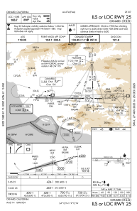
IAC chart of KOXR
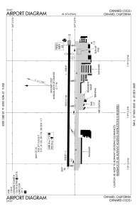
 ADC chart of KOXR
 Satellite view of KOXR
ADC chart of KOXR
Satellite view of KOXR
Sorry, we have no imagery here.
Sorry, we have no imagery here.
Sorry, we have no imagery here.
Sorry, we have no imagery here.
Sorry, we have no imagery here.
Sorry, we have no imagery here.


KOXR - Oxnard
Located in Oxnard, United States
ICAO - OXR, IATA -
Data provided by AirmateGeneral information
Coordinates: N34°12'3" W119°12'26"
Elevation is 44 feet MSL.
Magnetic variation is 15° East View others Airports in California
Operational data
Special qualification required
Current time UTC:
Current local time:
Weather
METAR: KOXR 170851Z AUTO 28005KT 9SM OVC010 14/11 A2997 RMK AO2 SLP147 T01390111 51002
TAF: KOXR 170811Z 1708/1806 25004KT P6SM BKN023 FM171100 29005KT P6SM BKN012 OVC023 FM171600 27008KT P6SM SCT014 OVC028 FM171900 27014G22KT P6SM FEW014 BKN028 FM180200 28012KT P6SM BKN019 FM180400 29006KT P6SM BKN014
Communications frequencies: [VIEW]
Runways:
| RWY identifier | QFU | Length (ft) | Width (ft) | Surface | LDA (ft) |
| 07 | 91° | 5953 | 100 | ASPH | 5954 |
| 25 | 271° | 5953 | 100 | ASPH | 5500 |
Airport contact information
Address: Oxnard United States
Other aviation service providers
Repair station

Flight schools

Ventura County Flight Training Center
Ventura County Flight Training Center
alison.barker@calaero.com+1(805)201-0688
Satellite view of KOXR
Sorry, we have no imagery here.
Sorry, we have no imagery here.
Sorry, we have no imagery here.
Sorry, we have no imagery here.
Sorry, we have no imagery here.
Sorry, we have no imagery here.