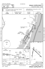
IAC chart of KOXB
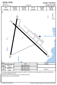
 ADC chart of KOXB
 Satellite view of KOXB
ADC chart of KOXB
Satellite view of KOXB
Sorry, we have no imagery here.
Sorry, we have no imagery here.
Sorry, we have no imagery here.
Sorry, we have no imagery here.
Sorry, we have no imagery here.


KOXB - Ocean City Muni
Located in Ocean City, United States
ICAO - OXB, IATA -
Data provided by AirmateGeneral information
Coordinates: N38°18'38" W75°7'26"
Elevation is 15 feet MSL.
Magnetic variation is -12° East View others Airports in Maryland
Operational data
Special qualification required
Current time UTC:
Current local time:
Weather
METAR: KOXB 180753Z AUTO 33006KT 10SM FEW095 OVC120 21/13 A2968 RMK AO2 SLP051 T02060133
Communications frequencies: [VIEW]
Runways:
| RWY identifier | QFU | Length (ft) | Width (ft) | Surface | LDA (ft) |
| 02 | 10° | 3204 | 75 | ASPH | |
| 20 | 190° | 3204 | 75 | ASPH | |
| 14 | 133° | 4074 | 75 | ASPH | |
| 32 | 313° | 4074 | 75 | ASPH |
Airport contact information
Address: Ocean City United States
Other aviation service providers
Flight schools

Satellite view of KOXB
Sorry, we have no imagery here.
Sorry, we have no imagery here.
Sorry, we have no imagery here.
Sorry, we have no imagery here.
Sorry, we have no imagery here.