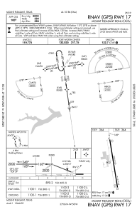
IAC chart of KOSA
 Satellite view of KOSA
Satellite view of KOSA
Sorry, we have no imagery here.
Sorry, we have no imagery here.
Sorry, we have no imagery here.
Sorry, we have no imagery here.
Sorry, we have no imagery here.
Sorry, we have no imagery here.


KOSA - Mount Pleasant Rgnl
Located in Mount Pleasant, United States
ICAO - OSA, IATA -
Data provided by AirmateGeneral information
Coordinates: N33°5'49" W94°57'42"
Elevation is 364 feet MSL.
Magnetic variation is 04° East View others Airports in Texas
Operational data
Special qualification required
Current time UTC:
Current local time:
Weather
METAR: KOSA 191535Z AUTO 17012G16KT 10SM BKN023 27/23 A2977 RMK AO2 T02690227
Communications frequencies: [VIEW]
Runways:
| RWY identifier | QFU | Length (ft) | Width (ft) | Surface | LDA (ft) |
| 17 | 172° | 6004 | 100 | ASPH | |
| 35 | 352° | 6004 | 100 | ASPH | |
| H1 | 0° | 0 | 0 | UNK |
Airport contact information
Address: Mount Pleasant United States
Satellite view of KOSA
Sorry, we have no imagery here.
Sorry, we have no imagery here.
Sorry, we have no imagery here.
Sorry, we have no imagery here.
Sorry, we have no imagery here.
Sorry, we have no imagery here.