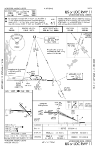
IAC chart of KORH
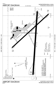
 ADC chart of KORH
 Satellite view of KORH
ADC chart of KORH
Satellite view of KORH
Sorry, we have no imagery here.
Sorry, we have no imagery here.
Sorry, we have no imagery here.
Sorry, we have no imagery here.
Sorry, we have no imagery here.
Sorry, we have no imagery here.


KORH - Worcester Rgnl
Located in Worcester, United States
ICAO - ORH, IATA - ORH
Data provided by AirmateGeneral information
Coordinates: N42°16'2" W71°52'32"
Elevation is 1009 feet MSL.
Magnetic variation is -15° East View others Airports in Massachusetts
Operational data
Special qualification required
Current time UTC:
Current local time:
Weather
METAR: KORH 250954Z AUTO 26006KT 9SM CLR 02/01 A2977 RMK AO2 SLP091 T00170011 $
TAF: KORH 250804Z 2508/2606 26008KT P6SM SCT004 TEMPO 2508/2511 BKN004 FM251200 26007KT P6SM BKN060 FM251400 26012G19KT P6SM SCT070 FM252300 26008KT P6SM SCT150
Communications frequencies: [VIEW]
Runways:
| RWY identifier | QFU | Length (ft) | Width (ft) | Surface | LDA (ft) |
| 11 | 94° | 7001 | 150 | ASPH | 7001 |
| 29 | 274° | 7001 | 150 | ASPH | 7001 |
| 15 | 138° | 5000 | 100 | ASPH | 5000 |
| 33 | 318° | 5000 | 100 | ASPH | 5000 |
Airport contact information
Address: Worcester United States
Other aviation service providers
Flight schools

Satellite view of KORH
Sorry, we have no imagery here.
Sorry, we have no imagery here.
Sorry, we have no imagery here.
Sorry, we have no imagery here.
Sorry, we have no imagery here.
Sorry, we have no imagery here.