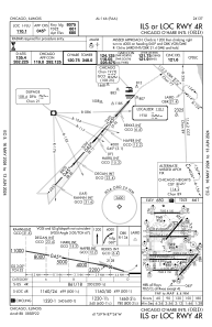
IAC chart of KORD
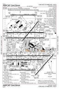
 ADC chart of KORD
 Satellite view of KORD
ADC chart of KORD
Satellite view of KORD
Sorry, we have no imagery here.
Sorry, we have no imagery here.
Sorry, we have no imagery here.
Sorry, we have no imagery here.
Sorry, we have no imagery here.
Sorry, we have no imagery here.


KORD - Chicago O'hare Intl
Located in Chicago, United States
ICAO - ORD, IATA - ORD
Data provided by AirmateGeneral information
Coordinates: N41°58'37" W87°54'29"
Elevation is 680 feet MSL.
Magnetic variation is -03° East View others Airports in Illinois
Operational data
Special qualification required
Current time UTC:
Current local time:
Weather
METAR: KORD 291051Z 21009KT 10SM SCT055 BKN250 16/10 A2981 RMK AO2 SLP091 T01610100 $
TAF: KORD 290905Z 2909/3012 23012G22KT P6SM SCT100 WS020/24060KT FM291000 21014G24KT P6SM SCT040 BKN100 TEMPO 2921/2924 P6SM -SHRA BKN035 FM300000 02011KT 6SM BR VCSH BKN010 FM300600 18011KT P6SM VCSH BKN008
Communications frequencies: [VIEW]
Runways:
| RWY identifier | QFU | Length (ft) | Width (ft) | Surface | LDA (ft) |
| 04L | 39° | 7500 | 150 | ASPH | |
| 22R | 219° | 7500 | 150 | ASPH | 7300 |
| 04R | 42° | 8075 | 150 | ASPH | 8075 |
| 22L | 222° | 8075 | 150 | ASPH | 8075 |
| 09C | 90° | 11245 | 200 | CONC | 11245 |
| 27C | 270° | 11245 | 200 | CONC | 11245 |
| 09L | 90° | 7500 | 150 | CONC | 7500 |
| 27R | 270° | 7500 | 150 | CONC | 7500 |
| 09R | 90° | 11260 | 150 | OTHER | 11260 |
| 27L | 270° | 11260 | 150 | OTHER | 11260 |
| 10C | 90° | 10800 | 200 | CONC | 10540 |
| 28C | 270° | 10800 | 200 | CONC | 10800 |
| 10L | 90° | 13000 | 150 | OTHER | 12246 |
| 28R | 270° | 13000 | 150 | OTHER | 13000 |
| 10R | 90° | 7500 | 150 | CONC | 7500 |
| 28L | 270° | 7500 | 150 | CONC | 7500 |
| H1 | 0° | 0 | 0 | UNK |
Airport contact information
Address: Chicago United States
Satellite view of KORD
Sorry, we have no imagery here.
Sorry, we have no imagery here.
Sorry, we have no imagery here.
Sorry, we have no imagery here.
Sorry, we have no imagery here.
Sorry, we have no imagery here.