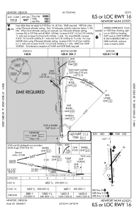
IAC chart of KONP
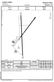
 ADC chart of KONP
 Satellite view of KONP

ADC chart of KONP
Satellite view of KONP
Sorry, we have no imagery here.
Sorry, we have no imagery here.
Sorry, we have no imagery here.
Sorry, we have no imagery here.
Sorry, we have no imagery here.
Sorry, we have no imagery here.


KONP - Newport Muni
Located in Newport, United States
ICAO - ONP, IATA -
Data provided by AirmateGeneral information
Coordinates: N44°34'49" W124°3'29"
Elevation is 160 feet MSL.
Magnetic variation is 15° East View others Airports in Oregon
Operational data
Special qualification required
Current time UTC:
Current local time:
Weather
METAR: KONP 180235Z AUTO 32007KT 10SM BKN027 BKN044 BKN050 07/03 A3018 RMK AO2
TAF: KONP 180235Z 1803/1824 29007KT P6SM SCT027 BKN045 BKN050 FM180400 28006KT P6SM -SHRA SCT030 BKN060 FM180800 27005KT P6SM -SHRA BKN045 FM181500 22005KT P6SM -SHRA BKN035
Communications frequencies: [VIEW]
Runways:
| RWY identifier | QFU | Length (ft) | Width (ft) | Surface | LDA (ft) |
| 02 | 37° | 3001 | 75 | ASPH | 3001 |
| 20 | 217° | 3001 | 75 | ASPH | 3001 |
| 16 | 177° | 5398 | 100 | ASPH | 5398 |
| 34 | 357° | 5398 | 100 | ASPH | 5098 |
Airport contact information
Address: Newport United States
Satellite view of KONP
Sorry, we have no imagery here.
Sorry, we have no imagery here.
Sorry, we have no imagery here.
Sorry, we have no imagery here.
Sorry, we have no imagery here.
Sorry, we have no imagery here.