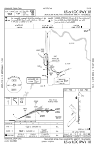
IAC chart of KOKM
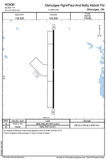
 ADC chart of KOKM
 Satellite view of KOKM

ADC chart of KOKM
Satellite view of KOKM
Sorry, we have no imagery here.
Sorry, we have no imagery here.
Sorry, we have no imagery here.
Sorry, we have no imagery here.
Sorry, we have no imagery here.
Sorry, we have no imagery here.


KOKM - Okmulgee Rgnl/Paul And Betty Abbott Fld
Located in Okmulgee, United States
ICAO - OKM, IATA -
Data provided by AirmateGeneral information
Coordinates: N35°40'5" W95°56'55"
Elevation is 719 feet MSL.
Magnetic variation is 04° East View others Airports in Oklahoma
Operational data
Special qualification required
Current time UTC:
Current local time:
Weather
METAR: KOKM 191935Z AUTO 28019G33KT 10SM OVC041 08/M02 A2988 RMK AO2 T00761024
Communications frequencies: [VIEW]
Runways:
| RWY identifier | QFU | Length (ft) | Width (ft) | Surface | LDA (ft) |
| 18 | 180° | 5150 | 101 | CONC | |
| 36 | 0° | 5150 | 101 | CONC |
Airport contact information
Address: Okmulgee United States
Satellite view of KOKM
Sorry, we have no imagery here.
Sorry, we have no imagery here.
Sorry, we have no imagery here.
Sorry, we have no imagery here.
Sorry, we have no imagery here.
Sorry, we have no imagery here.