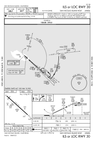
IAC chart of KNSI
 ADC chart of KNSI
 Satellite view of KNSI
ADC chart of KNSI
Satellite view of KNSI
Sorry, we have no imagery here.
Sorry, we have no imagery here.
Sorry, we have no imagery here.
Sorry, we have no imagery here.
Sorry, we have no imagery here.
Sorry, we have no imagery here.


KNSI - San Nicolas Island Nolf
Located in San Nicolas Island, United States
ICAO - NSI, IATA -
Data provided by AirmateGeneral information
Coordinates: N33°14'23" W119°27'30"
Elevation is 506 feet MSL.
Magnetic variation is 12° East View others Airports in California
Operational data
Special qualification required
Current time UTC:
Current local time:
Weather
METAR: KNSI 071753Z 32010KT 7SM CLR 17/07 A3012 RMK AO2 SLP196 T01670072 10167 20100 51008 $
Communications frequencies: [VIEW]
Runways:
| RWY identifier | QFU | Length (ft) | Width (ft) | Surface | LDA (ft) |
| 12 | 133° | 10002 | 200 | OTHER | 9010 |
| 30 | 313° | 10002 | 200 | OTHER |
Airport contact information
Address: San Nicolas Island United States
Satellite view of KNSI
Sorry, we have no imagery here.
Sorry, we have no imagery here.
Sorry, we have no imagery here.
Sorry, we have no imagery here.
Sorry, we have no imagery here.
Sorry, we have no imagery here.