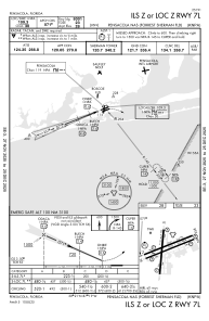
IAC chart of KNPA
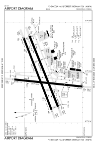
 ADC chart of KNPA
 Satellite view of KNPA

ADC chart of KNPA
Satellite view of KNPA
Sorry, we have no imagery here.
Sorry, we have no imagery here.
Sorry, we have no imagery here.
Sorry, we have no imagery here.
Sorry, we have no imagery here.
Sorry, we have no imagery here.


KNPA - Pensacola Nas (Forrest Sherman Fld)
Located in Pensacola, United States
ICAO - NPA, IATA -
Data provided by AirmateGeneral information
Coordinates: N30°21'12" W87°19'5"
Elevation is 28 feet MSL.
Magnetic variation is -03° East View others Airports in Florida
Operational data
Special qualification required
Current time UTC:
Current local time:
Weather
METAR: KNPA 170056Z 31004KT 10SM CLR 18/02 A2998 RMK SLP153 T01780017
Communications frequencies: [VIEW]
Runways:
| RWY identifier | QFU | Length (ft) | Width (ft) | Surface | LDA (ft) |
| 01 | 0° | 7136 | 200 | ASPH | |
| 19 | 0° | 7136 | 200 | ASPH | |
| 07L | 0° | 8001 | 200 | ASPH | |
| 25R | 0° | 8001 | 200 | ASPH | |
| 07R | 0° | 8000 | 200 | ASPH | |
| 25L | 0° | 8000 | 200 | ASPH |
Airport contact information
Address: Pensacola United States
Satellite view of KNPA
Sorry, we have no imagery here.
Sorry, we have no imagery here.
Sorry, we have no imagery here.
Sorry, we have no imagery here.
Sorry, we have no imagery here.
Sorry, we have no imagery here.